


2022-07-18_16h07m53_lAOIHpnW0Pg

pidjam
User
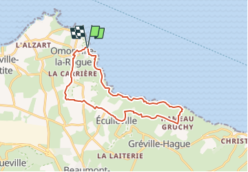

Length
13.1 km

Max alt
118 m

Uphill gradient
285 m
Km-Effort
16.9 km

Min alt
1 m

Downhill gradient
286 m
Boucle
Yes
Creation date :
2022-07-18 14:07:53.723
Updated on :
2022-08-09 16:43:11.672
3h50
Difficulty : Difficult

FREE GPS app for hiking
 SityTrail
IGN / Geographical institutes
SityTrail Plus
The world is yours!
About
Trail Walking of 13.1 km to be discovered at Normandy, Manche, La Hague. This trail is proposed by pidjam.
Positioning
Country:
France
Region :
Normandy
Department/Province :
Manche
Municipality :
La Hague
Location:
Omonville-la-Rogue
Start:(Dec)
Start:(UTM)
583892 ; 5506552 (30U) N.
Comments